
DatMapR is a Windows application which provides a flexible tool for creating maps from location record data in text and numeric format – such data includes biological records, land-use statistics, or simply a list of location references. The data can be provided in a variety of formats and the mapping can be based on a wide range of parameters defined by the user. Oh, and its FREE!!
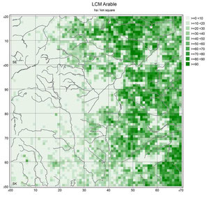
The example on the right is a simple map, produced using DatMapR, showing the distribution of Arable Land around Sheffield (that's Sheffield, UK!). It is based on data extracted from the Countryside Information System (http://www.cis-web.org.uk/).
More examples are available on the Example Maps page, together with a few words about them.
Take a look at a more complete outline of DatMapR in the Outline Page.
What DatMapR isn't!
A quick word about what DatMapR isn't - to save you from having to read further should you be looking for something different.
It's NOT a GIS tool - it doesn't create a map from Shape, MapInfo Mid/Mif, or other GIS data formats. I might get round to adding some possible GIS-type alternatives to the Links page as time allows - Do you have any suggestions? Feel free to add a note to the Guestbook.
It's NOT a biological records management system - it might well be used to produce maps from such data, but it isn't a place to hold and manage the data. I have added some suggestions on the Links page.
It's NOT an online tool – though it can (from v1.4) be used to Export KMZ files for use in Google Earth.
It WON'T do complex calculations or statistical manipulation on the data to be mapped. My suggestion would be to use something like Excel to do the calculations, then Save your data as a text file. Then DatMapR can be used to produce a presentable map from the data. DatMapR WILL do simple calculations such as counting, summing or averaging of appropriate values.
And it doesn't make coffee. But did I mention that it is FREE!

